


The City of Kigali has recently announced an innovative initiative to deploy satellite technology aimed at monitoring construction activities across the capital. This move is part of a broader strategy to combat illegal construction practices and ensure compliance with building regulations.
Overview of the Initiative
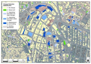
Kigali’s Mayor, Samuel Dusengiyumva, revealed that the city will utilize satellite-enabled technology to track construction developments in real-time. This system is designed to identify unauthorized constructions and verify the legitimacy of building permits. The mayor emphasized that this technology will allow the city to monitor new constructions weekly, enabling swift action against illegal developments before they are completed[1].
Objectives and Benefits
The primary goals of this satellite monitoring system include:
- Detection of Illegal Construction: The technology will help identify structures built without proper permits, thereby addressing rampant illegal construction practices.
- Integration with Existing Systems: The satellite data will be integrated with Kigali’s online construction permit system, facilitating easier verification of permit authenticity[1].
- Enhanced Urban Planning: By providing accurate data on land use and building activities, the initiative aims to improve urban planning and management in Kigali. This is particularly crucial as the city faces challenges related to rapid urbanization and the need for affordable housing[2].
Technological Framework
The satellite monitoring system has been tested successfully and is expected to be accessible via mobile devices for both city officials and residents. It can provide insights into whether new constructions align with approved permits and can even indicate changes in land use over time. This capability is essential for managing urban sprawl and ensuring sustainable development practices[1][3].
Challenges Addressed
Kigali’s rapid urban growth has often led to unplanned developments, which pose significant challenges for infrastructure and service delivery. The deployment of satellite technology is a proactive measure to address these issues by:
- Preventing Erosion and Land Misuse: The system will also help identify areas where construction may lead to environmental degradation, such as in hilly regions lacking proper water management[1].
- Supporting Affordable Housing Initiatives: With a target of building 18,000 affordable housing units annually, this monitoring system will play a critical role in ensuring that new developments meet regulatory standards while addressing housing shortages[1].
Conclusion
The City of Kigali’s initiative to deploy satellite technology for construction monitoring represents a significant step towards modernizing urban management in Rwanda. By leveraging advanced technology, Kigali aims not only to curb illegal construction but also to enhance overall urban planning efforts, ensuring that the city’s growth is sustainable and well-regulated. As this program unfolds, it may serve as a model for other cities facing similar challenges in the developing world.